This NSF project is “CAREER: The Influence of Distributed River Inputs and Coastal Embayments on Dynamics in Large Estuaries.” The principal investigator is Mike Whitney. The project is designed to transform the understanding of the effects of distributed rivers and coastal embayments on dynamics in large estuaries like the Long Island Sound (LIS). The hypotheses to be tested are:
1) Wind-driven and tidal straining of across-estuary density gradients is quantitatively as large as straining of along-estuary gradients
2) Distributed river inputs create focused areas of increased straining and areas of reversed straining conditions
3) During storm response, smaller river inputs from coastal watersheds collectively have a first-order influence on circulation and density structure
4) River waters follow regular transport pathways that shift during wind events
5) Coastal embayments transition from areas of net mixing to increased stratification as tidal currents decrease along the estuary.
The corresponding research objectives for the modeling project are:
1) Run hydrodynamic simulations for the LIS and couple a surface-runoff model for coastal watersheds;
2) Analyze results to quantify straining conditions and the combined influence of the smaller river inflows;
3) Determine transport pathways for fresh water from the distributed river inputs; and
4) Quantify the effects of coastal embayments on estuarine circulation and density structure.
Bathymetry is one influence on freshwater transport pathways in estuaries. A distinctive bathymetric feature in LIS is Mattituck Sill, located several kilometers west of the Connecticut River mouth. The paper “Sill effects on physical dynamics in eastern Long Island Sound” indicates Mattituck Sill deflects more of the Connecticut River plume waters towards the mouth; consequently, less freshwater enters central LIS.

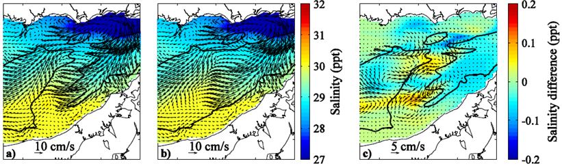
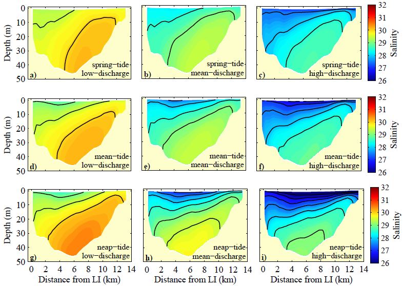
A manuscript in preparation entitled “Subtidal exchange in eastern Long Island Sound” by Mike Whitney, Dan Codiga, and Dave Ullman finds that the overall salinity structure and tidal-averaged current patterns are similar for a wide range of tidal and river discharge conditions. There is an outward-flowing low-salinity wedge on the south side with an inward-flowing higher-salinity area underneath and to the north. Stratification and freshwater flux increase for stronger river discharge and weaker tides. Salinities are much more sensitive to forcing changes than velocities. The hierarchy of forcing factors influencing salinities, velocities, exchange fluxes, and net freshwater flux is river discharge followed closely by tidal modulation and then episodically changed by wind events (especially in winter months).

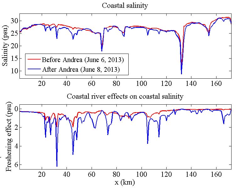
Another manuscript in preparation is “An Investigation into the Distribution, Mixing, Residence Time, and Storm Response of Coastal River Waters in Long Island Sound” by Steve Schmidt and Mike Whitney. This study combines watershed models with the estuary-shelf hydrodynamic model to assess the relative influence of freshwater from the Connecticut (the largest source), intermediate rivers (Pawcatuck, Thames, Quinnipiac, Housatonic, and Hudson via the East River connection), and numerous smaller rivers with coastal watersheds. Results indicate Connecticut River waters are found throughout LIS, the intermediate rivers are most important for the western LIS, and the smaller coastal river waters make up a significant fraction of the freshwater only in a narrow coastal band near their river mouths. These coastal rivers have a disproportionally strong response to coastal rain events (e.g. Tropical Storm Andrea remnants in June 2013) that decreases coastal salinities and modulates along-estuary salinity gradients near the coast.


Tracking how waters from each river are distributed throughout LIS has implications for water quality issues, since each river has its own finger print of nutrient, sediment, and contaminant concentrations. This research already has had broader interdisciplinary impacts, by helping interpret results from a Connecticut Sea Grant project on organic contaminants. The study concluded that other sources besides the Housatonic contributed to organic contaminants in the LIS region outside the Housatonic mouth. Model results from the NSF CAREER project suggest that a significant portion of freshwater in this area is from the Connecticut River, Quinnipiac, and nearby smaller coastal rivers. Environmental managers have expressed interest in exploring these techniques for source attribution purposes in water contamination issues.